8 stages · 327 km

Gradients and elevation

Ascents: 5038m
Descents: 4168m
Lowest point: 204m
Highest point: 1458m

8 stages used

Moulins / Chantelle

12 Moulins / Chantelle

68 km
5 h 00 min
Hard
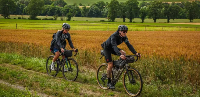
This undulating GTMC Gravel stage presents cyclists with a variety of landscapes and atmospheres, plus you’re afforded the first staggering views of the Auvergne’s volcanic ranges. First, though, you cross Moladier Forest, then join the banks of the Allier.
Next, you ascend to plateaux planted with vineyards in the Saint-Pourçain wine-making area. Verneuil-en-Bourbonnais, a charming, characterful village, offers an ideal place to rest your studded tyres! Cross the steep-sided, refreshing Bouble Gorges to reach Chantelle and its abbey.
Chantelle / Riom

13 Chantelle / Riom

56 km
5 h 00 min
Hard
Continuing along the GTMC Gravel from Chantelle to Riom, the volcanic range of the Chaîne des Puys stands temptingly in your line of vision. You quickly reach Charroux, a member of the association Les Plus Beaux Villages de France, with many craftspeople based here.
Then follow the Sioule River as far as Ebreuil, tackling a fairly hilly portion of route. The rest of this stage offers you more and more expansive views onto the volcanoes, captivating you all the way. Coming down to the flat Limagne agricultural plain, the views prove particularly wonderful, with the historic town of Riom and the iconic Puy de Dôme volcano looking splendid.
Riom / Clermont-Ferrand

14 Riom / Clermont-Ferrand

23 km
2 h 15 min
Average
Having crossed the village of Marsat, you enter a wonderful stretch of countryside. As you head up into the hills, enjoy the varied views, onto the Limagne Plain, Riom and Clermont-Ferrand, the last with its cathedral built from black volcanic stone and the test circuits for the Michelin tyre company famously based in the city. At Chateaugay, cellars line up, carved into the basalt rock, recalling the long wine-making past of this village. After you’ve scaled Le Bancillon Pass, dip down into the lively centre of the Auvergne’s historic and administrative capital, Clermont-Ferrand.
Clermont-Ferrand / Volvic

15 Clermont-Ferrand / Volvic

21 km
2 h 00 min
Hard
Historic Clermont-Ferrand was formerly the starting point for the original GTMC mountain bike route. From town, you head gradually up to the Chaîne des Puys Range, distinguished by its 80 volcanoes and dominated by the largest, the massively impressive Puy de Dôme. Admire the exceptionally varied landscapes below the Puy de Dôme, going from the 2,000-year-old city to sunny slopes planted with vines and fruit trees. This stage ends amidst chestnut woods and ancient volcanic flows, which have given rise to distinctive vegetation and architecture.
Cycling in these parts, your gaze will be irresistibly drawn to the volcanoes. The stage ends at the little town of Volvic, famed for its mineral water naturally filtered through volcanic rock.
Volvic / Laschamps

16 Volvic / Laschamps

40 km
4 h 00 min
Hard
This stage of the GTMC cycle route alternates between stretches on roads with motorized traffic and playful tracks leading you through a string of villages surrounded by utterly enchanting landscapes, and through the Chaîne des Puys volcanic range.
After the town of Volvic, you start along a stretch of road before you get down to the real cycling business, guided along very good tracks in the direction of the Puy de Chopine volcano.
Here, in the midst of the Chaîne des Puys volcanic range, the countryside is both magnificent and exceptional, with splendid views to admire.
Laschamps / Murol

17 Laschamps / Murol

45 km
4 h 30 min
Hard
This GTMC stage guides you gradually into the Massif du Sancy, another magnificent mountain range. Pause to visit the imposing Basilique Notre-Dame-des-Fers, one of the old Auvergne Region’s most significant Romanesque churches. And plan to picnic beside Servières Lake before launching yourself into the vast pasturelands and higher mountain summer meadows that impart such a feeling of freedom as you cycle along. A pretty path through low woods leads to Pessade, a green resort in the heart of the countryside, a paradise for outdoor sports. You finish in style, arriving at Chambon Lake, which incites you to go swimming on fine days, enjoying the Massif du Sancy as sensational backdrop.
Murol / Saint-Alyre-ès-Montagne

18 Murol / Saint-Alyre-ès-Montagne

35 km
4 h 00 min
Hard
The views along this stage are magnificent, while the atmosphere changes dramatically along the way. After admiring the very beautiful medieval village of Besse, head on to the exceptional circular Pavin Lake, set in a volcano crater. Next comes Montcineyre Lake, a crescent-shaped volcanic lake. You’ve now entered the Cézallier area. Here, steep slopes are replaced by gentler, more rounded ones, the vast stretches of high summer pastures dotted with herds of cows. La Godivelle Nature Reserve preserves precious peat-bogs. Admire the Lacs d’En-Haut et d’En Bas before arriving at the hamlet of Jassy.
Saint-Alyre-ès-Montagne / Chalinargues

19 Saint-Alyre-ès-Montagne / Chalinargues

40 km
4 h 00 min
Hard
Leaving Jassy, the GTMC leads you up to the Col du Mont Chamaroux pass, then this pastoral track takes you to the summit of a plateau perched at 1,450m above sea level. From on high, admire the vast views of the Sancy Range and the volcanic French county of Cantal.
Relish the wonderfully long descent that ensues, lasting 6km! As you reach the end of the route through the Cézallier, you enter the département of Cantal. After Pradiers and Les Veyrines Waterfall, it’s Allanche next. Leaving that village, a slope takes you up to La Pinatelle Wood. Riding along broad forest tracks, you soon reach Chalinargues.
Afficher les étapes